The tropical outlook features potential development off the Southeast coast for the 4th of July … More
The 4th of July weekend is approaching, and the threat of something “tropical” is increasing for Florida and portions of the U.S. southeastern coast. Many popular beach destinations from Panama City to Myrtle Beach could be facing a holiday soaker due to a stalled frontal boundary and the potential development of a tropical or subtropical low pressure system. Here is the latest on what people in the Carolinas, Georgia, and Florida should expect, the timelines, and whether the storm could be named.
Forecast weather map for the 4th of July.
The Meteorological Explanation
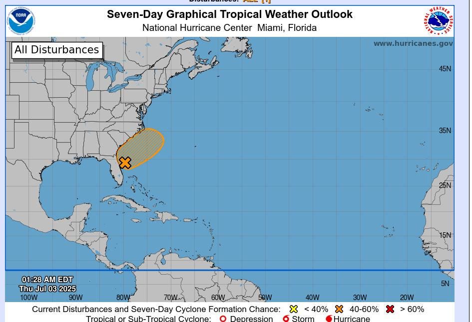
Let’s get straight to the reliable source. According to the National Hurricane Center discussion issued Thursday morning, “An area of low pressure is forecast to develop along a weakening frontal boundary near Florida or the Atlantic coast of the
southeastern United States by early this weekend.” While conditions are not optimal for explosive development, NHC went on to say that say that some slow development is possible. That could lead to a tropical or subtropical depression forming over the 4th of July weekend. At the time of writing, the chance of formation through 7 days is about 60 percent.
Risk of excessive rainfall from the morning of July 3, 2025 to July 4, 2025.
Likely Weather Impacts For Florida And Southeast Coast
Whether the storm gets a name or not, it will likely produce heavy rainfall across the northern half of Florida and southeastern coast. Through Friday, NOAA’s Weather Prediction Center expects the greatest likelihood of excessive rainfall in the western peninsula and marginal chances through coastal Georgia and South Carolina.
The National Weather Service in Charleston, South Carolina cautioned, “The current forecast features isolated to scattered afternoon showers and thunderstorms, mainly along the coast and firing off of the sea breeze. However, if the low is able to form, precipitation chances along the coastline would likely increase both Saturday and Sunday.”
Where Named Storms Typically Form Around The 4th Of July
I don’t expect a named storm out of this system. However, this is a pretty typical location for formation at this time of year. Favorable origin points tend to be in the eastern Pacific basin, the Gulf and off the southeastern U.S. coast. As hurricane season progresses into the peak months of August and September, origin points increasingly shift to the Atlantic main development region.
Typical formation points for tropical cyclones around July 4, 2025.
The second named storm of the year is typically expected in the middle of July. We have already had Tropical Storms Andrea and Barry. We are trending slightly ahead of the average pace right now. The third named storm usually forms in August. If this low forms and overperforms to reach named status, it would be called Chantal. The first hurricane of the year usually forms in the Atlantic basin around the second week of August. Forecasters are also currently watching Tropical Storm Flossie in the eastern Pacific basin.
The expected progression of named storms in an average Atlantic season.