Hurricane Erin rapidly strengthens to Category 5 storm near the Caribbean
Hurricane Erin rapidly exploded from a Category 3 storm to a massive Category 5 overnight and is on track to curve north between the U.S. East Coast and Bermuda next week, according to the National Hurricane Center.
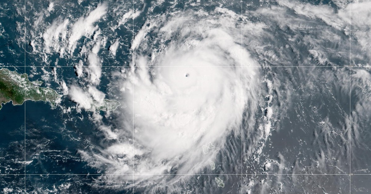
The major hurricane was about 110 miles north of Anguilla on Saturday afternoon and heading west at 16 mph, with maximum sustained winds of 160 mph, the hurricane center noted in an update at 2 p.m. ET.
Erin is expected to slow down and shift west-northwest Saturday night, then turn north early next week as it passes north of the Leeward Islands, the Virgin Islands and Puerto Rico this weekend. It will remain a major hurricane (Category 3 or higher) through midweek.
“Fluctuations in intensity are expected for the rest of the weekend,” the hurricane center said in an 11 a.m. update.
The storm is not forecast to hit land, but its strong winds are impacting nearby islands, prompting warnings of possible flooding and landslides, The Associated Press reported.
There are tropical storm watches in effect for St. Martin, Sint Maarten and St. Barts, according to the hurricane center. A tropical storm warning was also issued for the Atlantic offshore waters of Puerto Rico, according to the National Weather Service field office in San Juan.
Video circulating on social media showed palm trees in St. Croix blowing in the strong winds already taking aim at the U.S. Virgin Islands on Saturday afternoon.
Turks and Caicos and the southeastern Bahamas should also keep an eye on the storm, the hurricane center advised.
Those in Leeward Islands, Puerto Rico and the Virgin Islands can expect heavy rainfall with the possibility of 2 to 6 inches, the hurricane center said.
In Sint Maarten, the Dutch half of St. Martin, there is a flood advisory and a small aircraft advisory, according to the country’s government.
“We urge all residents and visitors to exercise caution and stay alert,” the country’s government warned, highlighting areas that are prone to flooding, including Arch Road and Beacon Hill Road.
The Virgin Islands also have a flood watch in effect through Monday evening, according to the Government House.

“Locally, considerable flash and urban flooding, along with landslides or mudslides, are possible,” the hurricane center said.
Erin will generate large, powerful waves that are forecast to affect Hispaniola, Turks and Caicos, the Virgin Islands, Puerto Rico and the northern Leeward Islands through the weekend, according to the hurricane center.
The hurricane center warned that life-threatening surf and rip currents could hit the Bahamas, the East Coast of the U.S. and Atlantic Canada next week.
Urban and small stream flood advisories were issued for the islands of St. Thomas and St. John until 6 p.m. AST on Saturday, according to the weather service’s field office in San Juan.
“These swells will spread to the Bahamas, Bermuda, and the east coast of the United States early next week,” the hurricane center said. “These rough ocean conditions will likely cause life-threatening surf and rip currents.”
Erin is the fifth storm to be named in the 2025 Atlantic hurricane season, but the first to reach hurricane status, The Associated Press reported. Hurricane season starts on June 1 and ends on Nov. 30.
The storm is the only Category 5 hurricane on record to form this early in the hurricane season, and the only Category 5 observed outside the Gulf or Caribbean this early in the year. It is also the 11th Category 5 hurricane in the past decade.
This year’s hurricane season is now the fourth consecutive season with a Category 5 hurricane.


Steve Strouss, Christine Rapp and Leslie Ignacio contributed.