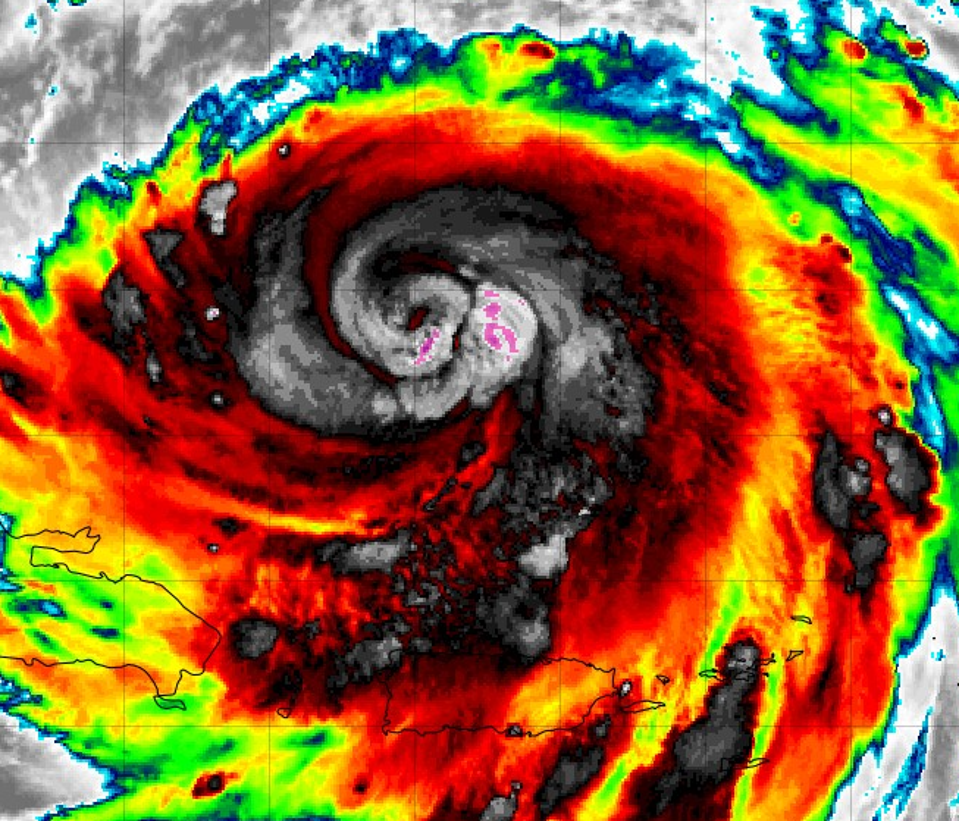
Satellite image of major Hurricane Erin on Sunday morning August 17, 2025.
NOAA and Tropical Tidbits website
Outer rainbands from Hurricane Erin continue to strike Puerto Rico, the U.S. Virgin Islands, and other territories for hours. At 8 am AST, Erin is still a dangerous major hurricane with sustained winds of 125 mph. It is moving in a generally west-northwest direction at 14 mph and has caused the government of the Bahamas to issue tropical storm watches and warning for the region. What’s expected for the U.S. mainland?
Hurricane Erin moving just north of Puerto Rico on the morning of August 17, 2025. The islands have been affected by the outer rainbands for much of the weekend.
Marshall Shepherd via Radarscope
A Soaking In Puerto Rico And Other Islands
At the time of writing, Erin is a Category 3 storm, but it reached Category 5 intensity on Saturday morning. It exhibited an extreme case of rapid intensification by going from Category 1 on Friday evening to Category 5 by Saturday morning. As the storm passed north of Puerto Rico, outer bands with strong storms have inundated the U.S. territory and other islands in the region. Isolated rainfall amounts approaching 4 to 8 inches will continue to pose the threat of flooding, landslide, and mudslide threats on these islands.
Hurricane Erin rainfall forecast.
NOAA
Hurricane Erin Is Growing In Size
The latest model guidance and the official forecast of the National Hurricane Center predicts that Hurricane Erin will not make landfall in the U.S. As a reminder, landfall is defined by the National Weather Service as, “The intersection of the surface center of a tropical cyclone with a coastline.” I included the definition because many people assume that impacts from rainbands constitute landfall. For this reason, we emphasize that hurricanes are not dots or lines on a map. They can have broad impacts well beyond the center of the storm.
Something else that I saw on social media is that Erin might get to Category 6. First off, there is no such thing, and I have opined on that assertion in the past. Here is the more important point. Though Erin’s rate of intensification was impressive, those comments overlook a key self-limiting process that happen with strong hurricanes. These types of storms often go through an eyewall replacement cycle or ERC. What’s that?
It is a process in which the original eyewall contracts once a relative intensity threshold is reached. As the original eyewall gets smaller, intensity starts to weaken and a new, broader eyewall replaces it. The good news with an ERC is that the storm losses strength, but the bad news is that the storm often gets larger in physical size. A broader storm can extend impacts, and that is what has happened with Hurricane Erin over the past several hours. For these reasons, I despise the term “downgraded” in a situation like this because it may send the wrong message to people.
This satellite image provided by NOAA shows Hurricane Erin on Saturday, Aug. 16, 2025. (NOAA via AP)
Associated Press
Though an ERC has taken a bit of Erin’s punch, it is now a larger storm, which in some ways makes it more dangerous. It also still has a favorable environment ahead of it. The hurricane will soon traverse 86-to-88 degree Fahrenheit waters. The National Hurricane Center forecasters wrote, “The quick weakening over the past 6 to 12 hours is associated with Erin’s structural changes and not environmental conditions. Since the large-scale environment is expected to be favorable for about another day, re-strengthening is possible during that time period.”
They also acknowledged something that many of us in the meteorological community understand well. Intensity forecasts are trickier than track forecasts. They cautioned, “However, it should be noted that predicting the intensity evolution from internal dynamics are challenging, and models often provide little reliability in their solutions. Beyond 24 to 36 hours, a broadening of the wind field and some increase in shear should cause gradual decay in the peak winds.”
Waters are very warm ahead of Hurricane Erin.
NOAA and Tropical Tidbits website
What Does All Of This Mean For The Mainland U.S.?
It means that a powerful and large storm will skirt between the East Coast and Bermuda by the middle of the week. Currently, the storm has been doing its version of the wobble and is a bit south of its previous track. NHC stated, “This ridge is expected to break down later today due to a series of troughs moving across the northwestern Atlantic.” What does that mean? It is the atmospheric transition that should cause Erin to turn to the north and then northeast. On the predicted track, Erin will skirt to the east of the Bahamas at the beginning of the week so appropriate watches and warnings have been issued by their government.
There is one subtle change to note. Hurricane Erin will track between the U.S. and Bermuda, but the larger physical size means outer bands could impact the U.S. coast by midweek. At a minimum, dangerous swells and rip currents should be expected along the eastern U.S. coast. NHC cautioned, “Interests along the North Carolina and Mid-Atlantic coasts, and Bermuda should monitor the progress of Erin as there is a risk
of strong winds associated with the outer rainbands during the middle part of the week.”
Forcast track for Hurricane Erin as of August 17, 2025.
NOAA