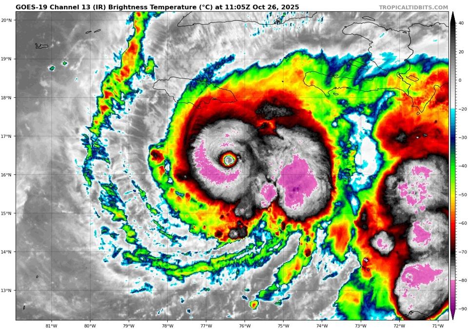
Hurricane Melissa was a strong Category 4 on Oct. 26, as it lingered near Jamaica. It has since become a Category 5 storm.
NOAA and Tropical Tidbits website
Update, Oct. 27: This article was originally published Oct. 26. It has been edited with new details about Hurricane Melissa’s Category 5 status and path.
Hurricane Melissa, as expected, explosively intensified and is now a dangerous Category 5 storm as of Monday morning. Winds of 175 mph have been detected as the storm approaches Jamaica. It is expected to make a direct landfall in Jamaica and, eventually, Cuba.
Here are four things you need to know about Hurricane Melissa right now.
It Is A High-End Major Hurricane
Hurricane Melissa underwent extreme rapid intensification over the weekend. “Its intensity has increased by 50 kt over the past 24 hours and 35 kt over the past 12 hours,” the National Hurricane Center wrote Sunday morning. As a reference point, 50 kt is equivalent to 57.5 mph, and we define rapid intensification as gaining 35 mph of maximum wind speed in less than 24 hours. Melissa gained 40 mph of maximum wind speed in half of that time.
University of South Alabama weather expert Jordan McLeod wrote Sunday on Facebook, “Exactly what I feared. Hurricane Melissa has rapidly intensified into a Category 4 hurricane ahead of schedule. In my opinion, it’s not a matter of whether Melissa reaches Category 5 status today. That appears to be almost a certainty at this point. Regardless, the extreme impacts to Jamaica remain the same.” He was right.
Melissa continued to strengthen and became a rare Category 5 storm by Monday morning, reaching wind speeds of 175 mph. Meteorologist Matt Cappucci of MyRadar Weather Radar posted Monday afternoon that Hurricane Melissa is now the 10th strongest Atlantic hurricane on record in terms of wind speed.
Expected track of Hurricane Melissa. Updated on Monday Oct. 27, 2025, at 2 p.m. EDT.
NOAA
Current Residents Have No Experience With A Direct Hit From A Category 4 or 5 Hurricane
There could be intensity fluctuations, but it is very likely that Hurricane Melissa will make landfall in Jamaica as a Category 4 or 5 hurricane on Tuesday. The storm is already very close to the island. It will linger for a couple of days before making an abrupt turn toward Jamaica. Hurricane Beryl (2024) passed relatively quickly last year. My fear is that “recency bias” will cause people to anchor in that experience, and that would be a dangerous mistake. The dwell time of Melissa is part of this unfolding disaster story.
Track of Hurricane Gilbert (1988), which made landfall in Jamaica as a Category 3 storm
NOAA
Geographer Cary Mock is an expert on hurricane climatology at the University of South Carolina. He wrote on social media, “No Category 5 hurricanes for Jamaica that I know of, but a very slow-moving hurricane with a bunch of rain, hit Jamaica in October 1815.” Mock uses old newspaper articles, ship logs and other resources in his historical research. Hurricane Gilbert was a devastating storm in 1988 that caused $700 million in damage and killed nearly 50 people, but like Beryl, it moved out. It was a Category 3 storm when it struck Jamaica, though it intensified afterwards. According to UPI, the island has never recorded a direct landfall by a Category 4 or 5 storms, and that’s surprising.
Rainfall Will Be Measured In Feet For Some Areas
Melissa will lash Jamaica sometime by Tuesday evening. The storm will likely make a second landfall in eastern Cuba. That region along with western Haiti, the Dominican Republic and, eventually, the Bahamas will also experience extreme impacts.
Because of the slow forward speed, rainfall amounts will be measured in feet for many places. Parts of Jamaica, Cuba, Haiti and the Dominican Republic will experience nearly 2 feet of rainfall. Candidly, 3 feet or more of rainfall are possible in some regions, particularly mountainous terrain. Flooding, landslides and mudslides are likely.
Expected rainfall totals updated on Monday, Oct. 27, 2025
NOAA
Timing For Impacts And Expected Scope
NHC wrote a dire message Sunday morning to the people of Jamaica: “Seek shelter now. Damaging winds and heavy rainfall today and on Monday will cause catastrophic and life-threatening flash flooding and numerous landslides before the strongest winds
arrive Monday night and Tuesday morning.” It noted that catastrophic infrastructure damage, communication outages, long-duration power and community isolation are expected. Deadly storm surges will be present along the southern coast, too.
In southwestern Haiti and the Dominican Republic, life-threatening flash flooding and
landslides will also lead to isolation and infrastructure damage, according to NHC. Eastern Cuba, Turks and Caicos and the southern Bahamas will need to monitor Melissa. It will likely be a hurricane after it crosses Jamaica.
Hurricane chaser Josh Morgerman has experienced the eye of many hurricanes, cyclones and typhoons around the world. Morgerman collects data on these storms at landfall and provides perspective on the severity of these events. As he arrived in Jamaica, his words on his public Facebook page paint a real but grim picture: “But it’s not just about penetrating the hurricane’s core. Establishing a solid homebase—and human relationships around it—is important on extreme island expeditions like these, because they’re often extended stays. The hard truth is, if MELISSA hits Jamaica at the forecast intensity—which would be quite extreme—I’m gonna be on this island for a while.”
Sadly, we are looking at a possible generational disaster emerging.
A man boards up a hotel’s windows in preparation of Hurricane Melissa’s expected arrival in Kingston, Jamaica, Saturday, Oct. 25, 2025. (AP Photo/Matias Delacroix)
Copyright 2025 The Associated Press. All rights reserved