
The first geological map of the United States was published in 1809 by William Maclure, a Scottish naturalist who in 1796 decided to emigrate to the U.S. Maclure had made a fortune as a merchant, so he was economically independent to pursue his geological interests, and a workaholic, dying during a field survey aged 76. Yet his map covers only the eastern half of the country. Since then, generations of geologists have expanded his map, with new theories, like plate tectonics or magmatic differentation, changing our views on how to understand the distribution of rock formations. Geological maps are updated to this day to meet the needs and interests of modern society.
“Geologic maps have many uses, such as helping experts look for energy, mineral and water resources,” explains Christopher Swezey, a U.S. geological survey geologist involved in creating the new map. “They can also be used to assess earthquake risks and inform decisions about land use, infrastructure and community planning, and real estate and insurance.”
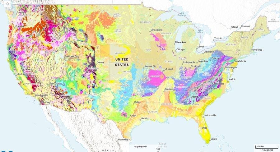
Geologic maps use different colors to show various types of rocks and sediments beneath the surface. These are organized into geologic map units, which range in composition from loose sand and gravel to very old bedrock. Each unit or formation has its own unique characteristics, such as age and composition.
The new USGS map, called The Cooperative National Geologic Map, was created using more than 100 preexisting geologic maps from various sources and is the first nationwide map to provide users with access to multiple layers of geologic data.
The new interactive web tool was designed to be as user friendly as possible, making it accessible to both geologists and the public. Users can search for specific properties of geologic units or click on the map for additional geologic information and links to more detailed maps of local areas.
“This map provides complete, analysis-ready geologic data for the nation, in a format that is easy to expand going forward,” says Joseph Colgan, a USGS research geologist and leader of the team that created the map. “By providing this map online, we aim to enhance educational engagement and foster a greater public appreciation of geology.”
In addition to public use, it is anticipated that primary users of the map will include federal agencies, private industries, and educational institutions. A recent cost-benefit study highlighted the usefulness of geologic maps with its findings that the value of geologic maps is up to 10 times greater than the cost of their production.
Additional material and interviews provided by the USGS.