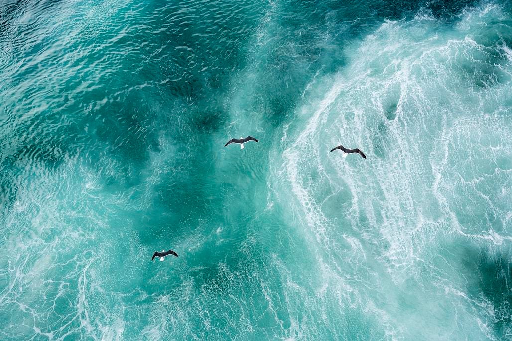
Three doves flying over North Atlantic
Earth’s oceans make up the life blood of our planet, 70% of which is covered by water. Yet as a recent European Space Agency-led initiative indicates human activities, mainly in the form of noise from seafloor mining, oil drilling and commercial fishing, are wreaking havoc on a large swath of the Atlantic Ocean. Pelagic species, such as migratory birds, large fish, turtles, cetaceans and mammals including whales, dolphins and porpoises, are particularly under threat.
A recent paper published in the journal Marine Pollution Bulletin notes how satellite imagery of the Atlantic can be used to define a methodology to protect 30% of the ocean seascape, which provides important habitats for these pelagic species, says ESA.
This study focuses on the Atlantic high seas, where fishing and shipping are the main human activities, and noise and pollution are the biggest environmental pressures, Marie-Helene Rio, an ESA Ocean Scientist based at the space agency’s ESRIN facility in Italy, told me via email.
Funded by ESA’s Science for Society Biodiversity in the Open Ocean: Mapping, Monitoring, and Modeling project, the study used satellite data primarily from ESA’s ENVISAT satellite the agency’s Copernicus Sentinel-3 to define biodiversity zones, says ESA. The authors of the study note that it’s likely possible to protect 30% of ocean habitats, with little impact on fishing and shipping.
The bottom line is that areas beyond national jurisdiction – the so-called high seas – make up about two-thirds of the oceans, but only 1.45% of these habitats are protected, says ESA. And arguably, the biggest offender is noise pollution from human activity that can be disruptive and damaging to marine habitats.
That’s because such noise pollution can affect how cetaceans communicate and hunt, says Rio. It also affects fish populations by interfering with their ability to sense their environment, their ability to mate, communicate and avoid predators, she says.
This image shows human activity, including cargo ships, tankers, passenger ships and fishing … More
As for how the study was carried out?
First, we characterized both shipping and fishing activities and the distributions of different species, Asier Anabitarte, a researcher at the Sustainable Fishing Technologies group of Spain’s AZTI, told me via email. And we excluded the main shipping lanes (areas of high activity concentration connecting countries or continents) and then proposed areas to be protected, he says.
The study area covers the high seas of the whole Atlantic Ocean, from 65 degrees South latitude to 65 degrees North latitude and from 90 West longitude to 25 East longitude. But it excludes the Exclusive Economic Zones (EEZ), which fall under the jurisdiction of each country.
How important were these satellite observations?
Satellites were crucial to provide the global picture, says Rio. While the parameters used for the study (Chlorophyll, sea surface temperature) can be measured in-situ, she says. Only satellites provide the necessary global and repetitive coverage needed to dynamically map the seascapes, says Rio.
A Complex Challenge To Marine Life
The loss of marine biodiversity in the Atlantic is due to many different pressures, often acting simultaneously, says Rio. Overfishing is one of the major and more direct threats to marine biodiversity, she says.
But climate change also plays a role in biodiversity loss.
Climate change is also a systemic driver of such loss, says Rio. Climate change threats to our oceans include sea warming, ocean acidification due to the ocean absorption of anthropogenic carbon dioxide emissions, as well as the intensification of tropical cyclones, she says.
To counter a portion of such threats, a 2023 United Nations agreement, known as Biodiversity Beyond National Jurisdiction, seeks to establish protected areas in 30% of the world’s oceans by 2030, says ESA.
Measuring Marine Biodiversity
Marine biodiversity and ocean health is the ultimate and largely unknown parameter that needs to be integrated into our models if we ever want to monitor, understand, and predict planetary health, says Rio.
Next Generation Threat
Beginning in the next decade, ESA’s suite of next generation Copernicus Sentinel earth-observing satellites should fill in some of the gaps in our current knowledge of the health of our our oceans.
These missions will provide essential information to further improve our knowledge of the ocean and of the many drivers threatening its health, says Rio.