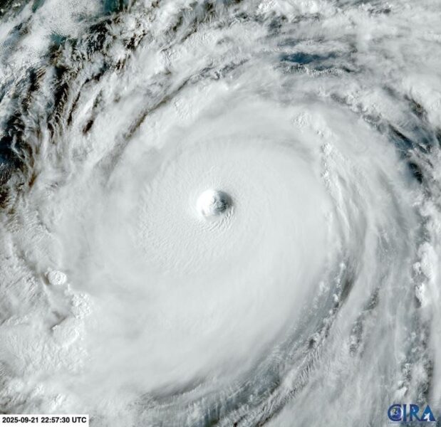

Visible satellite image of Super Typhoon Ragasa on Monday, September 22, 2025.
RAMMB/CIRA
Super Typhoon Ragasa has roared into view, standing out this season—not just for what it has done, but for what it is. As the strongest tropical cyclone of 2025 so far, Ragasa is testing how well societies, infrastructure, and forecasting systems can respond in a rapidly changing climate.
As of this writing, Ragasa has disrupted more than 700 flights, work, school and transport has been suspended in multiple cities, and over 40,000 people have been evacuated. Described as the “most powerful storm on Earth so far this year,” Ragasa is expected to cause billions of dollars in damage.
To understand Ragasa, and why it matters, you need to know what a “super typhoon” is—how it compares with hurricanes, and what makes this storm especially dangerous.
Ragasa Threatens Millions Across Asia
Ragasa (locally named Nando in the Philippines) developed in mid-September over the Western Pacific. The storm originated north of Yap, gradually organizing as it tracked across exceptionally warm ocean waters under favorable atmospheric conditions. By September 22, it had intensified into a super typhoon, with maximum sustained 1-minute winds reaching 165 mph — the equivalent of a Category 5 hurricane.
Japan’s Himawari-9 satellite has captured striking images of Super Typhoon Ragasa – known locally as Nando in the Philippines – bearing down on the Babuyan Islands on Monday and causing massive disruptions to industries across the region.
Himawari-9 satellite
The Philippines, Taiwan, and southern China remain in Ragasa’s projected path. In the Philippines, the storm has already triggered large-scale evacuations, widespread power outages, and warnings for heavy rainfall, storm surge, flooding, and landslides — with Northern Luzon bearing the brunt so far.
What Is The Difference Between A Hurricane, Typhoon and Super Typhoon?
You might hear “hurricane” used in general conversation to describe any big storm, but in technical meteorology these names and categories have specific geographical and intensity distinctions.
In the Western North Pacific, tropical cyclones are formally classified by their maximum sustained wind speeds. Once winds reach at least 74 mph, the system is called a typhoon. Meteorologists may also evaluate central pressure and structural features such as the eye, eyewall, and outflow to understand a storm’s intensity, but the official classification is based on wind speed alone.
A super typhoon is an especially intense subset of these storms. The Joint Typhoon Warning Center applies this designation to typhoons with 1-minute sustained winds of at least 150 mph. The Philippine weather agency also uses “super typhoon,” though with a slightly different wind threshold, while the Japan Meteorological Agency does not use the term at all.
In the case of Ragasa, JTWC data showed maximum sustained winds near 165 mph. That places it well within the super typhoon category and, for context, equivalent in strength to a Category 5 hurricane in the Atlantic or Eastern Pacific basins.
The differences between a hurricane, typhoon and super typhoon.
DTN
The Rapid Intensification Of Ragasa Challenges Preparedness
What makes Super Typhoon Ragasa significant isn’t only that it reached “super typhoon” strength, but how rapidly and where it did so. The storm underwent unusually fast intensification as it neared northern Luzon and nearby islands, shrinking the time available for evacuations and preparedness. Peak winds approached 165 mph, with gusts even higher, and coastal communities were warned of storm surges exceeding 3 meters in low-lying or exposed areas.
You can track the storm on the Japan Meteorological Agency’s website. The region it threatens includes steep, landslide-prone terrain in northern Luzon and smaller islands such as Calayan and Batanes, as well as large population centers across southern China, Hong Kong and Taiwan.
Forecasting the exact track, rainfall distribution, storm surge, and wind impacts of a powerful western Pacific typhoon remains complex. This system’s path has placed several countries on alert, each with varying capacities for evacuation, infrastructure protection, and power restoration.
Super Typhoon Ragasa illustrates the upper end of tropical cyclone intensity in the region: Category 5-equivalent winds, a high storm-surge threat, rapid intensification, and danger to millions across islands and coasts.
As this season continues, Ragasa should serve both as warning and as data. Storms like this can teach us a lot—about forecasting, about adaptation, and about emergency planning. And they’ll test whether we’ve learned enough to be prepared for the next typhoon.