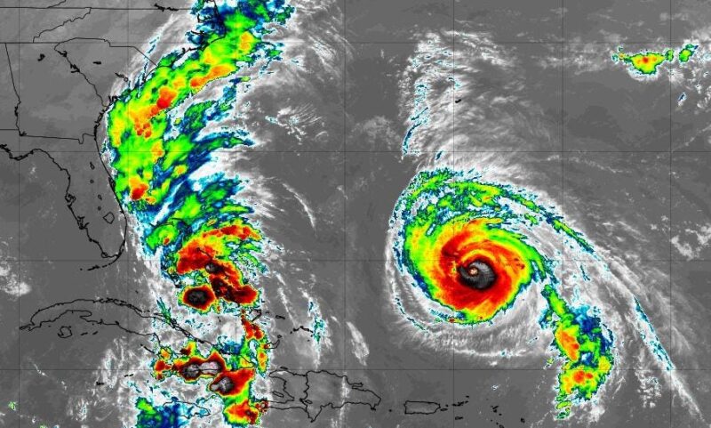
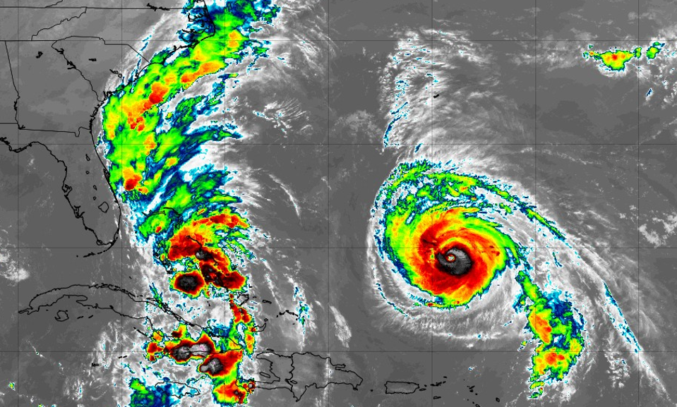
Weather satellite imagery on the morning of September 28, 2025 shows major Hurricane Humberto (right) and an an emerging system likely to become Tropical Storm or Hurricane Imelda.
NOAA and Tropical Tidbits website
Throughout the week I have written about the possibility of a tropical storm or hurricane making landfall in the Carolinas. That storm is forming and will likely be Tropical Storm Imelda at some point on Sunday. In previous discussions, I also mentioned uncertainty with the track forecast because of the presence of Hurricane Humberto and likely forecast model challenges until the storm forms. Thankfully, the models have a better handle on the situation and are signaling that Imelda will take a hard right out to sea. Here’s the meteorology behind why that is likely to happen.
Projected track of Hurricane Humberto.
NOAA and NWS
The Status of Hurricane Humberto
Hurricane Humberto is a strong storm with winds in excess of 155 mph. It is expected to curve out into the Atlantic Ocean and could bring impacts to Bermuda by the middle of the week. The National Hurricane Center said, “Swells generated by Humberto will continue to affect portions of the northern Leeward Islands, the Virgin Islands, Puerto Rico, and Bermuda through much of this week.” They noted that life-threatening rip currents and swells from Humberto and developing Imelda could impact the U.S. East Coast as well.
Projected track for future Tropical Storm or Hurricane Imelda.
NOAA and NWS
Why Will Imelda Take A Hard Right?
Why is Imelda expected to make such a hard right away from the U.S. mainland and what role is Humberto playing? At the time of writing on Sunday morning, the tropical depression that will become Tropical Storm Imelda is becoming better organized as it moves towards the Bahamas. The NHC Sunday morning discussion stated, “The initial motion is a bit faster to the north-northwest, or 345/6 kt. This general motion with a turn towards the north is anticipated during the next couple of days while the system moves between an upper trough over the southeastern United States and the subtropical ridge.”
Ridges (jagged line) and troughs (dashed lines).
NOAA
Yep, that is a lot of meteorological jargon, so I will explain it. Troughs, in the Northern Hemisphere, tend to be areas of low pressure that look like the letter “U” on middle-atmosphere weather maps. Ridges are areas of high pressure that may have more of an inverted “U” shape. In the graphic above, ridges and troughs are shown. The wind flows roughly parallel to the lines from west to east. Now, let’s examine what the NHC mentioned with the tropical depression.
Sunday morning middle atmosphere system of troughs and ridges.
NOAA and Tropical Tidbits website
A trough is situated over the Southeast and a ridge is over the Atlantic Ocean. Imelda’s escape route is situated between the two of them. NHC meteorologists explained later on Sunday morning, “Humberto’s larger outer circulation creates a large weakness. Given
the slow motion of the depression so far, it has also remained
south of a track bifurcation point that was seen yesterday in the
ensemble guidance. The tropical cyclone now appears more likely to
turn sharply east-northeastward.” Thankfully, that pathway is offshore and significantly reduces the likelihood of a U.S. landfall. NHC went on to say, “Beyond that time, models are generally faster and more offshore of the United States with the eventual track of the tropical cyclone, following the trend of the past few cycles, due to it missing the upper trough and eventually following Hurricane Humberto more out to sea.”
On Thursday, I wrote, “There is still some possibility of Humberto and the next storm, which will be named Imelda, interacting with each other. That “hurricane dance” is called the Fujiwhara effect. While it can be fascinating, it can also make track forecasting more challenging.” I explicitly mentioned, “Humberto could drag “Imelda” out to sea, or another low could nudge the storm toward the Carolinas. That seems to be the solution the models are buying for now, but it could change.” It changed. That’s why it is important to watch the evolving forecasts and guidance with proper context rather than provocative, “scary” posts by “social mediarologists.” Even with the latest scenario NHC forecasters cautioned that while the “hard right” scenario is the consensus position right now, “It is too early to feel extremely confident.”
Potential extent of Tropical Storm winds with Hurricane Humberto and the storm likely to become Imelda.
NOAA and NWS
As noted previously, some impacts for the U.S. are still expected, and a Tropical Storm Watch has been issued for the eastern-central coast of Florida. As development progresses and the storm moves northward, tropical storm winds, swells, and rainbands could swipe that region. There are also potential rainfall impacts for the Southeast.
Weather map for September 29, 2025.
NOAA
NOAA’s Weather Prediction Center wrote, “While a direct landfall is looking much less probable according to the latest forecast track from the National Hurricane Center, surges of deep tropical moisture associated with this system are still likely to interact with the stalled frontal boundary along the Southeast U.S. coastline, supporting at least the potential for a heavy rain and flash flooding threat.” The risk will depend on how close to the coast the tropical system gets before it slows down and then sharply turns out to sea, according to NOAA forecasters.
Potential rainfall with future Tropical Storm or Hurricane Imelda.
NOAA