We can’t monitor what we can’t see. At least that’s what the latest shark science study says, pointing out that water clarity is only one factor that comes into play when observing sharks via aerial methods.
getty
Sharks are often imagined cruising just beneath the waves, dorsal fin protruding from the dark, ocean waters to alert people of their incoming doom. At least, that’s how Hollywood depicts them. With this in mind, you would think they would be easily visible from the air as these predators patrol coastal waters. But the reality is there are over 500 species of sharks and most of them spend very little time near the surface.
Aerial surveys are increasingly used in the New York Bight and surrounding waters to track marine animals relative to offshore wind energy sites and to conduct long-term monitoring of protected species, including cetaceans and sea turtles. Recent increases in shark bites on water users have also prompted state officials to invest heavily in visual and aerial surveillance near beaches, deploying helicopters, drones, jet skis, boats, and lifeguards. Shark bite risk for water users remains extremely low, but a combination of factors (including increasing shark abundance, shifts in predator and prey distributions, and rising human attendance at beaches) can increase encounter probabilities. The mid-Atlantic coastal waters host over two dozen shark species, many of which are highly migratory and seasonal, with varying habitat preferences and stock assessments indicate that populations of some of these predators have been increasing in recent years following decades of conservation and fisheries management. Climate change is also driving northward shifts and longer seasonal residency for many species, making encounters more likely. There are gaps in understanding how population monitoring and beach safety strategies can be optimized, and many question how effective such aerial monitoring efforts actually are.
To better understand what is happening in New York waters, NOAA Fisheries shark researcher Dr. Tobey H. Curtis and a group of scientists tracked 150 individuals across 10 species using depth-sensing tags between 2017 and 2024. These species included sand tiger (Carcharias taurus), common thresher (Alopias vulpinus), white (Carcharodon carcharias), tiger (Galeocerdo cuvier), spinner (Carcharhinus brevipinna), blacktip (Carcharhinus limbatus), dusky (Carcharhinus obscurus), sandbar (Carcharhinus plumbeus), scalloped hammerhead (Sphyrna lewini), and smooth hammerhead (Sphyrna zygaena) sharks. The tags affixed to the individuals recorded swimming depths, and the researchers then paired the data with measurements of water clarity and wave height to assess how visible sharks are to planes, drones, or helicopters.
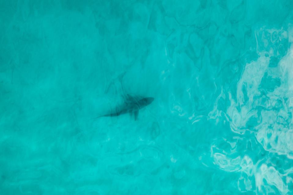
Even when the water looks full of sharks from above, most are actually deeper and largely invisible to aerial observers.
Getty Images
Despite overlapping ranges on the New York shelf, species showed distinct vertical habitat use patterns. Smooth hammerheads and blacktip sharks spent comparatively more time near the surface, whereas white sharks, spinner sharks, and dusky sharks were active throughout much of the water column. Sand tiger and sandbar sharks spent little time near the surface, staying closer to the bottom. These differences, the authors posit in their recent publication, likely reflects a combination of temperature, foraging strategy, prey availability, and distance from shore. And although many species are capable of much deeper swimming, the relatively shallow bathymetry of nearshore waters here likely constrained daytime depths. Five species (the common thresher, white, spinner, sandbar, and tiger sharks) reached maximum daytime depths exceeding 330 ft (100 m), yet mean depths remained less than 65 ft (20 m). These sharks may only occasionally explore deeper waters while spending most of their time closer to shore, where prey are concentrated. Even the most surface-oriented species, the smooth hammerhead, spent only about one-third of the time within 3 ft (1 m) of the surface. In fact, the sharks occupied the top 3 ft (1 m) of water — this is the zone where aerial detection is most feasible — only about 16 percent of the time. This means that even when you might think the water is full of visible sharks, most of the time they are actually deeper and effectively invisible to observers in the air.
Environmental conditions compound the challenge. Average summer water clarity was only 7 ft (2.1 m), and wave heights averaged 2.6 ft (0.8 m). Unlike regions such as southeast Florida or southern California, New York’s nearshore waters are frequently turbid and moderately rough, limiting the visibility of sharks from the air. Sun angle and glare can further interfere with detection, though drones with polarizing filters may partially improve observation. Even so, aerial methods alone are unlikely to provide reliable population assessments or real-time beach safety data. If anything, this new publication shines a light on a key limitation of aerial monitoring: you can’t monitor what you can’t see. The visibility of sharks is influenced not only by their depth, but various environmental factors at play. A plane flying overhead may see few, if any, sharks simply because most are swimming deeper than the camera can penetrate and the water is turbid; this creates what is called an “availability bias,” where the number of sharks detected actually underestimates the true number present. For public safety programs that rely on spotting sharks near beaches, or for scientists attempting to estimate population sizes, these biases mean aerial surveys provide only a partial and sometimes misleading picture.
Sharks can be elusive in ways that are not intuitive — afterall, their behavior is dynamic, varying by species, time of day, and environmental conditions. Tools like aerial surveys are valuable for spotting larger trends or occasional surface activity, yes, but they cannot reliably measure true abundance or guarantee timely detection for beach safety. Thus, complementary approaches such as acoustic monitoring, baited remote cameras, and tagging studies, are still needed to build an accurate understanding of shark populations and movements. Ultimately, the work of Curtis and his team shows that aerial monitoring is a limited tool in New York. And while that sounds like a negative thing, recognizing these limitations allows scientists and public safety officials to plan more effective strategies. It also reminds us that even in familiar coastal areas, much of the marine world remains hidden just below the surface, out of our reach. And to that leaves much to the imagination…